Paper Title: An affordable mobile LiDAR approach for efficient three-dimensional analysis of urban traffic
Author: Sassi Naoufal, Akourri Omar, Benbba Brahim
Corresponding Author: Benbba Brahim (b.benbba@uae.ac.ma)/Morocco
Abstract
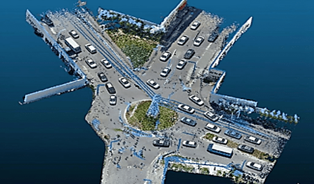
Urban mobility management is an issue that smart cities cannot ignore, and it requires reliable, sustained, and precise dynamic monitoring of traffic flows. This paper introduces a cost-effective mobile LiDAR-based methodology for three-dimensional urban traffic analysis, providing the high-resolution spatial data necessary for future AI-driven mobility decoding. We use real-world data acquisition rather than conventional studies that rely on traffic simulation tools, such as VISSIM or AIMSUN, to model traffic dynamics, including vehicle volumes, vehicle shapes, inter-vehicle distances, and automatic vehicle counting. The LiDAR system was a mobile system that used a terrestrial laser scanner (TLS) to capture high-density 3D point clouds at various urban intersections with no heavy infrastructure. The suggested methodology encompasses the whole processing chain, i.e., data collection, preprocessing, object segmentation, vehicle localization, volume estimation, and infrastructure element localization. The experiment at two intersections in the city of Tangier (Morocco) demonstrates that the obtained real-world LiDAR data is comprehensive, visually accurate, and suitable for training artificial intelligence models for traffic analysis and management. The proposed workflow provides a foundation of geometric data that could be used for future AI-based traffic analysis, following further annotation and model development.
Keywords
Urban traffic management, Mobile lidar, 3D point clouds, Artificial intelligence, Vehicle detection, Smart cities
Cite:
Naoufal, S. ., Omar, A. ., & Brahim, B. . (2026). An affordable mobile LiDAR approach for efficient three-dimensional analysis of urban traffic. Future Technology, 5(2), 336–346. Retrieved from https://fupubco.com/futech/article/view/798
